REST Services
ODOT’s annual state highway assets along with other frequently requested datasets can be accessed through our TransGIS REST Service Directory. Layers can be used in desktop GIS software (ArcMap or ArcGIS Pro), web mapping platforms (ArcGIS Online) or other compatible software/systems.
Data Download
Datasets can also be downloaded directly from our TransGIS Application with the following steps.
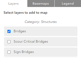
1. Select the desired layer from the Layers catalog. Activate it by selecting Submit.
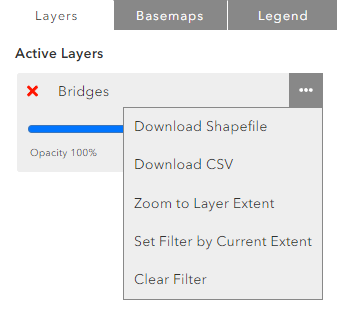
2. From the Active Layers menu select the three dot menu and choose your desired format.
Metadata
Please refer to the ODOT Geoportal for GIS metadata. The ODOT Geoportal does not contain GIS datasets, only the associated metadata document. Please be sure to carefully read the distribution liability statement in each file's metadata before use.
Other Data & Documents
Crashes
The following downloads include the full crash datasets with associated tables and relationship classes for the vintage year. Each download consists of an individual file geodatabase. Crashes can also be downloaded from TransGIS as a shapefile but will not include tables or relationship classes.
Crashes Supporting Documents
INRIX Shapefiles
Need Something Else?
Please contact us at odotmaps@odot.oregon.gov if you need help locating other data or have any questions.
Distribution Liability Statement
Please carefully read and consider the following distribution liability statement before using any of our data.
This product is for informational purposes and may not have been prepared for legal, engineering or surveying purposes.Users of this information should review or consult the primary data and information sources to ascertain the usability of the information.