
Oregon State Flag An official website of the State of Oregon »

Mobility


The Goal: A multimodal system that enables community members and businesses to get where they need to go safely, reliably, affordably, and with minimal environmental impact.


every-traveler-safe.png

How people move around our system is based on a series of individual choices. They consider what they can afford, can access, what is convenient, safe, or many other factors.

Any gaps or disruptions can prevent people from accessing jobs or critical services. These disruptions can affect individuals, families, or even whole communities.

Likewise, the flow of goods and freight truck movement is heavily impacted by the mobility of the system. An inefficient system leads to delays, uncertainty, and associated cost increases to businesses and consumers alike.

Our role is to ensure efficient movement of vehicles on interstates and highways, connecting bikeways and walkways along those routes, and supporting state and local transit service through funding programs. We support long-held state land use laws that keep trips short, meaning less travel and fewer roads, to get people and goods where they need to go. 

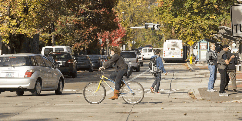
People in Oregon want multimodal options and less roadway congestion.

Mobility Topics

 roadwaycongestion.pngMultimodal subtopic.png

views_on_mobility.png


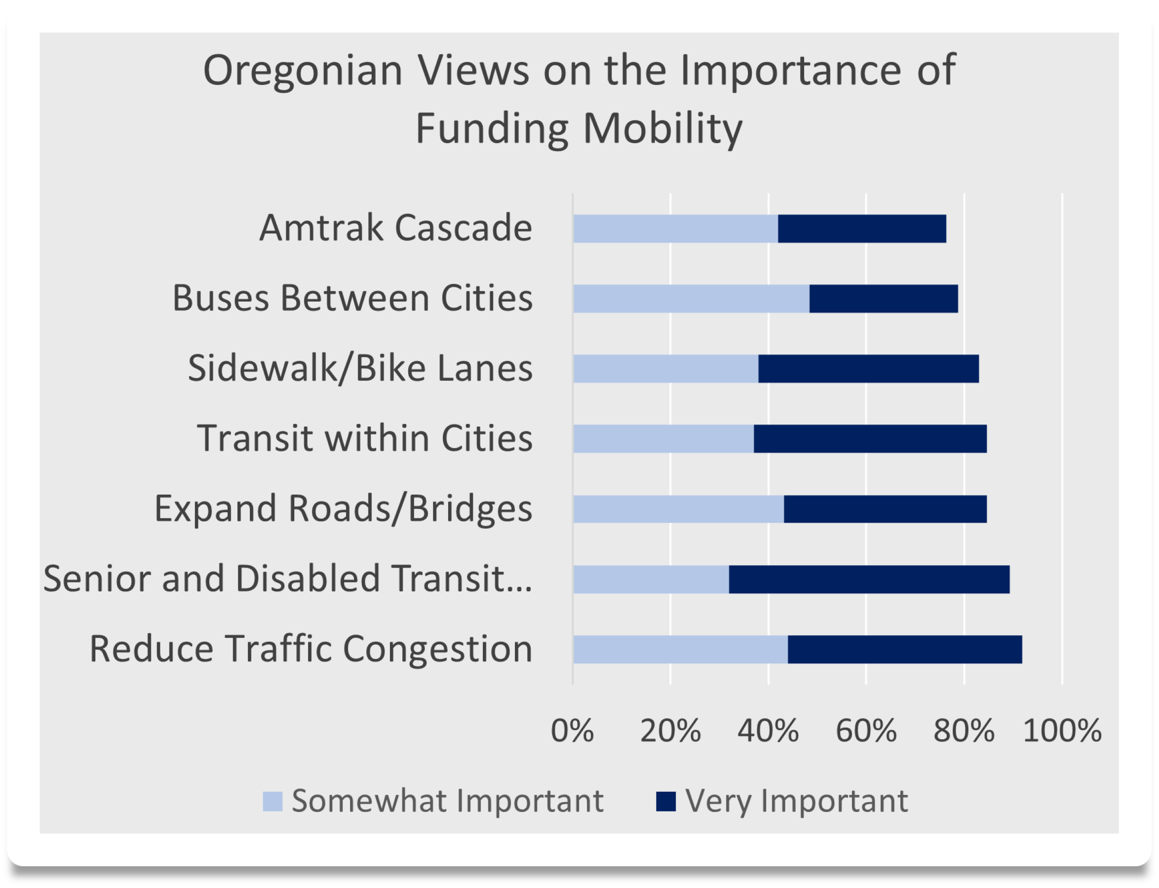
There is broad public support to use transportation dollars for multimodal options and to reduce traffic congestion. Public surveys indicate:

  • 9 out of 10 respondents put reducing traffic congestion as a priority for transportation spending.
  • 52% said they would take transit if service was added or improved in their area.
  • 42% said they would walk or bike if connections were added or improved in their area.
Source: Oregon Transportation Needs and Issues Survey (2023)


Roadway Congestion

Congestion means a slowdown or stop of traffic, usually due to a crash, the rush hour commute, or bad weather. Congestion can cause people to be late to everyday destinations and costs businesses more to ship or receive their goods.

We manage congestion by supporting the following to make roads more efficient:

  • non-driving modes like biking, walking or riding transit;
  • telecommuting;
  • transportation demand management; and
  • Intelligent Transportation System (ITS) and Active Management System (ATMS)

We know we can't build our way out of congestion, so our focus is on relieving specific bottlenecks and areas with high crash rates.


Oregon is seeing reductions in per capita VMT
  • Oregon population has increased 25% since year 2000, while statewide VMT only increased 9%.
  • Despite Oregon's population growth, per capita VMT has decreased 13%, meaning people are driving less on average. 
  • Passenger vehicles make up about 91% of VMT, heavy trucks about 6%, and medium sized trucks about 3%.
  • ODOT oversees 18% of state roadways and carries 59% of all VMT.


Statewide VMT is influenced by population growth, because more people generally means more travel. Per capita VMT (statewide VMT divided by population) reveals average per person travel, which has decreased over time.  


ODOT lane miles have grown less than 5% in the last two decades
In that time, Oregon infrastructure investment has focused on projects designed to improve system performance - especially in the areas of safety and reliability, but not adding large amounts of capacity to the system. The small amount of capacity building lane miles that have been constructed include adding auxiliary lanes, through lanes and truck-climbing lanes.

  • Just over 50 capacity adding lane miles have been built on our interstates/freeways since 2000, a .3% increase.


Roads are congested during commute times, especially in the Portland Metro area

Share_of_Miles.png
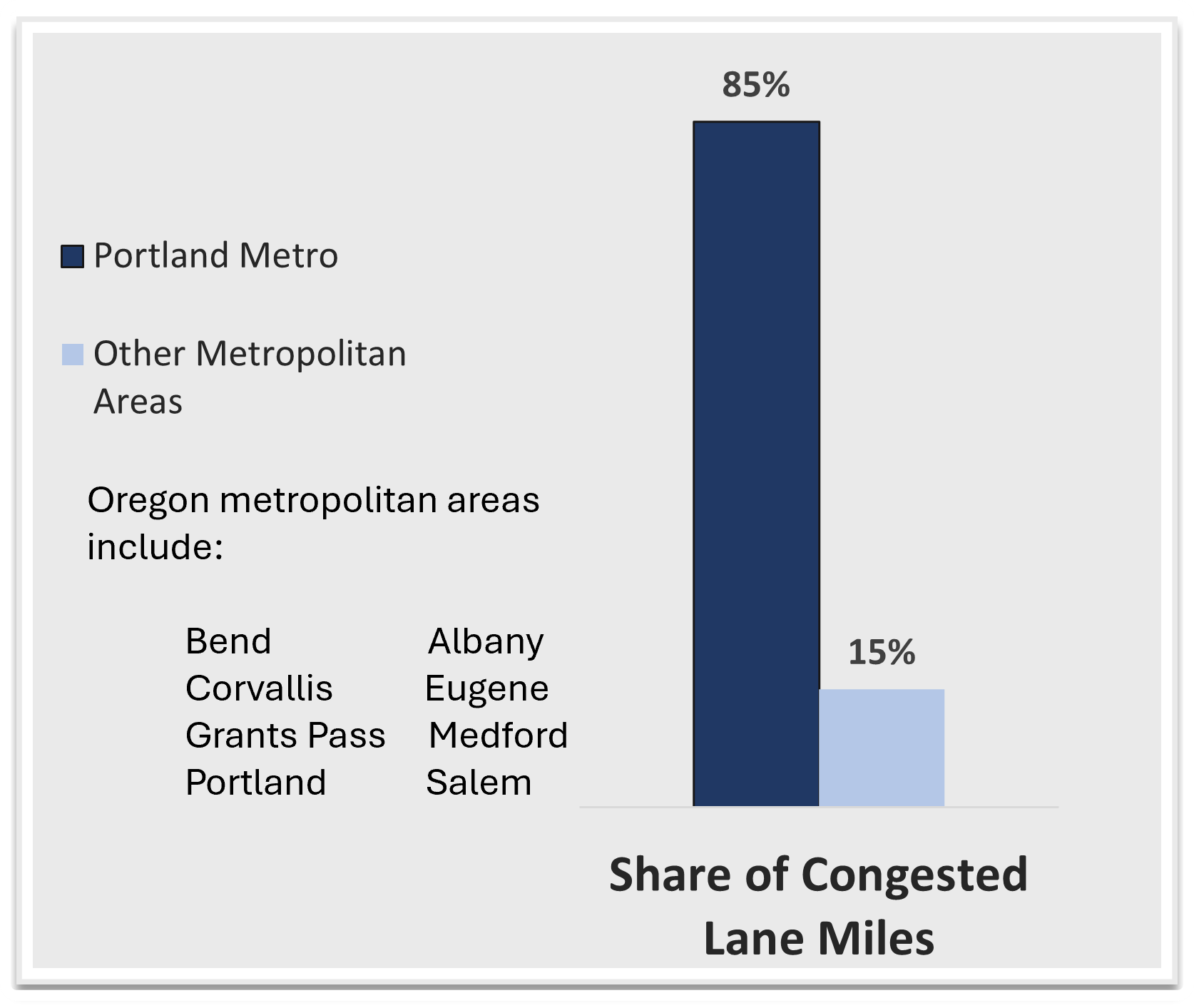
  • Each of Oregon’s urban areas has some level of congestion during peak hours but roads in the Portland Metro area are the worst. 
    • 85% of the congested lane miles statewide are in the Portland Metro area.
    • Portland Metro has locations ranked 28th and 30th on the nation's top truck bottlenecks. (Interstate bridge and I-5 at I-84)


Source: Top 100 Truck Bottlenecks - 2024, American Transportation Research Institute


Statewide Congestion Map: 2023 Weekday PM Peak


The Travel Time Index (TTI) is the ratio of the travel time during the peak period to the time required to make the same trip at free-flow speeds. A value of 1.5, for example, indicates a 30-minute free-flow trip requires 45 minutes during the peak period. This map shows congestion during peak periods on the Oregon freeway system. The higher the TTI value, the greater the congestion levels. Most congestion in Oregon is in the metropolitan areas, which can be seen by zooming into the map. 2023 congestion is mostly in the Portland area, but also in Eugene-Springfield and Albany. 


Travelers need to plan extra time to get where they need to go in Portland 

  • Travel time is unreliable on Portland's interstates and highways. For example, an evening trip on Interstate 5 could take 30 minutes longer on a day with particularly bad traffic when compared to an average day. As a result, people need to plan for more time (buffer) to get to where they need to go. 

Slowest Average Speeds.png Travel Time Buffer.png


ODOT Region1 Traffic Performance Report 2020 (update coming soon)   


Dealing with traffic congestion is not just inconvenient; it also costs people money and wastes their time

  • The daily cost of delay on highways and interstates in the Portland Metro region was $1.2 million in 2019. 
    • The cost of congestion is calculated based on fuel costs associated with idling, time lost sitting in traffic and other factors. 
  • Businesses that ship their goods are also affected by congestion. Delay and unreliable travel times impact their movement of goods, and businesses pass some of those costs on to customers. 


We are working to ease congestion in Portland


Investments have been sucessful in smoothing speeds and making travel times more consistent. For example: 

  • We extended small sections of merging lanes on I-205. This gave drivers more time to get on and off the interstate and resulted in an 11-minute improvmenet in trip reliability.
We created the Urban Mobility Strategy to reduce congestion in the Portland area, improve safety and modernize the region's aging transportation system. 

  • Major Urban Mobility Strategy projects are described in the table to the right.
We also partner with local jurisdictions and transit agencies to bolster transportation options within the region and along ODOT-owned roads.
Project
OR 217 Auxiliary Lanes Project- Our studies show that auxiliary lanes reduce crashes by 20-30%. This project includes adding new auxiliary lanes, on-ramp to off-ramp connections that give drivers more space and time to merge safely and improvements to the bicycle/pedestrian network.  

Estimated completion season/year: Fall 2025
I-205 Abernethy Bridge Project- A critical link connecting West Linn and Oregon City, this bridge will be the first earthquake-ready interstate bridge across the Willamette River in the Portland area. Includes bridge widening, improving nearby on- and off-ramps, and improving local bike and pedestrian routes. This is ODOT's largest construction project in 45 years.

Estimated completion season/year: Winter 2025-2026
I-5 Rose Quarter Improvement Project- Improves safety and congestion where three major interstates converge and reconnects the Albina neighborhood through the construction of a highway cover over a portion of I-5.

Estimated start date season/year: 2026 (We are exploring opportunities to advance early work.)
I-5 Boone Bridge Replacement Project- Replaces the existing bridge with one that can withstand a major earthquake. The new bridge will also enhance traffic flow, makes travel times more reliable, and improve safety.

Estimated start date season/year: Schedule to be determined based on funding availability.


Urban_Mobility_Office_link_button.png

Visit our Urban Mobility Office website to learn more 


2024-2028 Strategic Actions

2026 - Advance design and secure funding for construction of the I-5 Rose Quarter Improvements Project to provide smoother traffic flows, reduce crashes and enhance safety with ramp-to-ramp connections, and improve access for people walking, rolling and using transit.

2026 - Advance bridge tolling on the Interstate Bridge Replacement Program to provide revenue to modernize infrastructure, manage congestion, and support multimodal options.

2028 - Explore additional opportunities to expand bus on shoulder use in partnership with regional transit agencies and make additional state highway shoulder segments ready for bus on shoulder operations.

2028 - Actively participate in regional high-capacity transit project development.

2024 Efforts Underway

Strategic Action Plan
 
  • Finalizing grant agreement with USDOT for Project's Reconnecting Communities and Neighborhoods $450 million grant award.
  • Working to adopt Concept of Operations for I-205 Clackamas County BOS corridor.
  • Completed: TriMet "A Better Red" project (construction of a second track and new station for inbound Max Red Line riders entering Gateway Transit Center).
Other Ongoing Efforts
 
  • Improving TripCheck, our state travel information website.
  • Employing ramp meters to smooth traffic flow and reduce congestion from merging.
  • Deploying Incident Response Program to effectively manage unexpected events causing delays like crashes, weather and vehicle breakdowns.


2024-2028 Strategic Action Plan Outcome Area


Reduce Congestion in the Portland Region:
We will make everyday travel safer, more efficient and more predictable in the Portland metropolitan region.

Measuring Our Success: 
Decrease hours of congestion
Decrease Peak Travel Time Index


Our progress this quarter:

  • Completed Revised Supplemental Environmental Assessment and NEPA Decision Document


Multimodal

We are working hard to build a robust multimodal transportation system that ensures travelers have options like walkways, bikeways, rail and public transit to get them where they need to go safely, reliably, affordably and with little impact to the environment.

Frequency of Mode by Commuters.png 

More people are walking, biking and taking transit

  • Walk trips have increased nearly 60% in recent years. 
  • Many people in Oregon have commutes ideal for walking, biking or public transit: around 25% of commute trips are 3 miles or less, and just over 35% are 3-10 miles long.

                                                                Source: Oregon Transportation Needs and Issues Survey (2023)

Oregon’s walking and biking network is incomplete

  • We work with local partners to create safe, walkable, and bikeable communities, but only 45% of the bikeways and walkways needed within urban areas have been completed. There are:
    • 1775 miles of missing or substandard sidewalks.
    • 861 miles of missing state route bicycle infrastructure.
  • With current funding, it will take over 150 years to complete the network. 
  • Our incomplete network poses safety risks when people must walk or bike on the street without facilities to protect them. 

Sidewalk accessibility is improving 

We are responsible for much of the sidewalk, curb ramps and other roadway features that help make communities livable. This includes our ongoing work to bring more than 27,000 sidewalk curb ramps into compliance with Americans with Disabilities Act. We're upgrading existing ramps, adding new ones, and installing or upgrading pedestrian signals throughout the state to improve accessibility for people who walk, bike or roll. This work includes limited sidewalk improvements so additional improvements will be needed for complete accessible networks for sidewalks and transit stops.


Source: ADA Settlement Agreement Report Annual Report - 2023


Safe Routes to School program help kids access education safely

The Safe Routes to School programs work with schools to identify safety needs, provide education programs and safety gear, and make infrastructure investments.
 
  • $15 million is allocated annually to connect sidewalks and bike lanes, add or improve crossings, and ensure the roadways around schools are safe for kids to walk and bike. 
  • Unfortunately, that money isn’t enough to cover all needs, and the program is oversubscribed nearly 3:1. High schools are also newly eligible, which will lead to an even higher demand for this program. 
Explore ODOT funded Safe Routes to School projects below.

Oregon’s Payroll tax expands transit services statewide 

The payroll tax has tripled transit funding since 2019. It’s expanded transit hours, made service more frequent, and brought services to more people. 

stip.png  


Transit and Amtrak ridership is rebounding from pandemic travel shifts

Many people who do not drive rely on transit to reach critical services and destinations. Transit ridership dipped sharply in 2020 -2021 but many transit agencies are seeing a steady recovery in ridership. Much of this is due to state funding. 

Transit Ridership.png

  • Ridership for the Amtrak Cascades train in Oregon was 35% higher at the end of 2023 compared to 2019, and November and December 2023 exceeded all previous years’ ridership for those months. 
  • Despite a declining rural population throughout the U.S., there has been an 8.6% increase in per-capita rural ridership over the last 8 years. 

Sources: Oregon Transportation Information System, National Transit Database


People rely on transportation options

  • Nearly 20% of Oregon households include people who use transit at least once a week.
  • 9% of the driving age population does not have a drivers license.
  • Oregon’s population is aging; 19% of the state is age 65+.
  • Average age in rural areas is higher than urban, with fewer travel options.


Public_Transportation_link_button.png

Visit our Public Transportation website to learn more 


2024-2028 Strategic Actions

Annual - Continue to improve accessibility for people experiencing disabilities within the pedestrian network, fulfilling ADA commitments focused on curb ramps.

2025 - Evaluate investments made and refine and streamline grants and programs to prioritize investments that advance climate, vehicle miles traveled reduction, equity and safety outcomes (focusing on vulnerable users).

2026 - Enhance trip planning tools to better connect travelers from origin to
destination using multiple modes and integrate payment systems where feasible.

2028 - Define the multimodal network and establish priority corridors as part of the Oregon Highway Plan, to increase connectivity and access to key destinations, and integrate these corridors into investment decisions.


2024 Efforts Underway

Strategic Action Plan
 
  • Working to correct over 10% of non-compliant curb ramps planned annually.
  • Creating an annual evaluation questionnaire for grant program managers.
  • Working with neighbor states on new software that will imrpove transit services. 
Other Ongoing Efforts
 
  • Developing pedestrian and off-street path networks, including addressing missing sidewalks, curb ramps, and accessible pedestrian signals on road crossings.
  • Prioritizing safety, equity and addressing climate change in all the work we do, with a focus on the systems’ most vulnerable users (pedestrians and cyclists).


2024-2028 Strategic Action Plan Outcome Area


Improve Access to Active and Public Transportation:
We will provide increased transportation choices for people to reach their destinations by means other than driving.

Measuring Our Success: 
By 2028, achieve mobility targets for public transportation, passenger rail ridership, and pedestrian and bicycle network connectivity completeness. 
This metric monitors passenger rail ridership, transit rides, and walkway and bikeway infrastructure.


Our progress this quarter:

  • Completed Pedestrian and Bicycle Key Performance Measure update identifying pedestrian and bicycle priority corridors on ODOT right of way.