The instructions below are to help Oregon Centralized Application (ORCA) applicants navigate the
Oregon Housing Insights Tool as a criteria for the location preferences evaluation standard in the Impact Assessment ORCA step.
ORCA Applicants are required to meet certain location-based criteria to receive an initial conditional commitment for funding. One way to do so is by meeting two of the five criteria in the Anti-Displacement Index. All applicants must use data provided and published by Oregon Housing and Community Services (OHCS) when completing the ORCA Impact Assessment step. OHCS has produced a web mapping application tool that allows applicants to enter the address of a proposed project and determine if the site meets the Anti-Displacement Index criteria.
Displacement Risk Areas
For the ORCA, a census tract that is at risk of displacement, and thus meets that standard in the ORCA evaluation, is defined as a census tract meeting the criteria for at least two of the five given categories in the OHCS Anti-Displacement Index:
- Income Profile
- Vulnerable People
- Precarious Housing
- Housing Market Activity
- Neighborhood Demographic Change
Census tracts that meet more than two of the criteria will appear as yellow or red on the map.
Oregon Housing Insights Tool instructions
Step 1:
Access the
housing insights tool webpage.
Step 2:
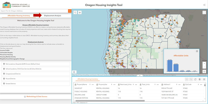
Click on the "Displacement Analysis" tab located below the search bar on the main page.
Step 3:
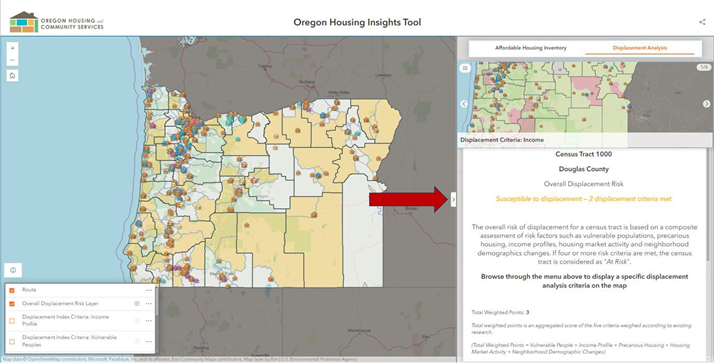
Click on the tab located on the info menu to reveal the search bar, then enter the address of the proposed project in the search bar (highlighted by the red box below) and click enter or the magnifying glass icon (if a project is scattered site, please include any applicable information for each site in your response).
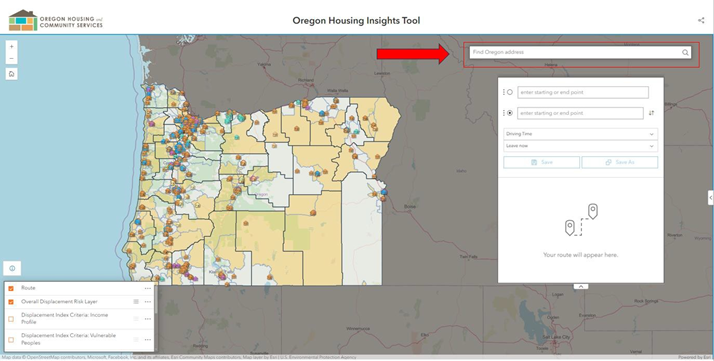
Use the + or – signs to the left of the search bar to zoom in or out (highlighted by the red box below).
Step 4:
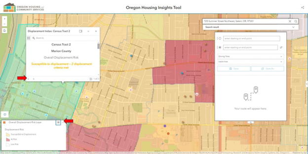
After the location is entered, click on the map to show the information menu for that area’s census tract. The primary layer will show the overall displacement risk information. Click on the arrow in the box to see its region information to determine if the census tract is rural or urban. Click on the map layer menu on the bottom left, to see the legend for each relevant layer or to change layer view to one of the other five displacement criteria layers, such as income profile.
For each layer you will see a box with the displacement criteria layer name with its corresponding information. You can also change the displacement layer from the feature menu.
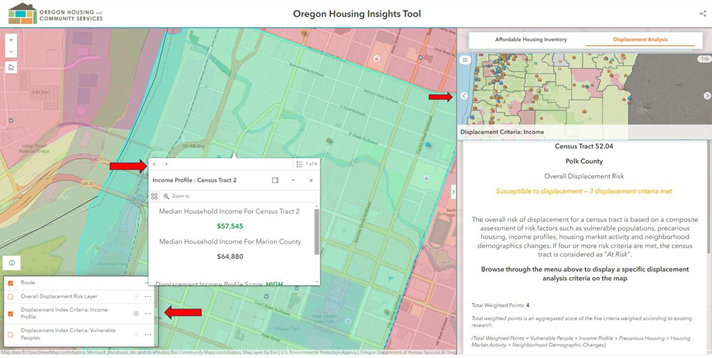
In the example below, the data table shows that the property is in Census Tract 2 in Marion County. For this census tract, the overall displacement risk is "susceptible to displacement". This means the property meets two out of the five criteria for the Anti-Displacement Index.
Tracts meeting two or three criteria are identified as susceptible to displacement, and colored yellow.
Tracts meeting four or give criteria are identified as at risk of displacement and colored red.
This is also clear from the layer menu on the left, showing yellow corresponds to “susceptible to displacement” and red to "at risk". Both categorizations can be used as a pathway for projects to meet the Location Preference standard in ORCA Impact Assessment. Use this menu to display the other displacement criteria and its information.
Use the main page, “Affordable Housing Inventory”, to view OHCS' affordable housing inventory and summary data about their surrounding neighborhood.
Example data table
Step 5:
Return to the ORCA Impact Assessment application questions document provided by OHCS to identify the criteria your project meets or does not meet that you found using the mapping tool.
This Mapping tool can also determine whether a site meets the opportunity area criteria. More details on the specific criteria can be found in the ORCA Manual under the Impact Assessment section. Please specify the criteria being claimed and what is being used to meet those criteria in the narrative below each section (e.g. identify the park that is less than a half mile from the property if applicable).