Frequently Asked Questions About Tsunamis
What is a tsunami?
A tsunami is a series of ocean waves most often generated by disturbances of the sea floor during shallow, undersea earthquakes. Less commonly, landslides and volcanic eruptions can trigger a tsunami. In the deep water of the open ocean, tsunami waves can travel at speeds up to 800 km (500 miles) per hour and are imperceptible to ships because the wave height is typically less than a few feet. As a tsunami approaches the coast it slows dramatically, but its height may multiply by a factor of 10 or more and have catastrophic consequences to people at the coast. As a result, people on the beach, in low-lying areas of the coast, and near bays and estuaries face the greatest danger from tsunamis. A tsunami can be triggered by earthquakes around the Pacific Ocean including undersea earthquakes with epicenters located only tens of miles offshore the Oregon coast. Over the last century, wave heights of tsunamis in the Pacific Ocean have reached up to 13.5 m (45 ft) above the shoreline near the earthquake source. In a few rare cases, local conditions amplified the height of a tsunami to over 30 m (100 ft).
 Click for
larger version
Click for
larger version
What is the difference between a Cascadia (local) tsunami and a distant tsunami?
An earthquake on the Cascadia subduction zone, a 1000-km- (~600-mile-) long fault zone that sits off the Pacific Northwest coast, can create a
Cascadia tsunami that will reach the Oregon coast within 15 to 20 minutes. Massive earthquakes of magnitude 9 or greater have been generated on the fault zone that probably produced strong shaking that endured for several minutes. A destructive tsunami can follow moments later.
A
distant tsunami produced by an earthquake far from Oregon will take 4 or more hours to travel across the Pacific Ocean, usually allowing time for an official warning and evacuation, if necessary. A distant tsunami will be smaller in size and much less destructive, but it can still be very dangerous.
Have tsunamis hit the Oregon coast?
Yes. Tsunamis triggered by nearby earthquakes offshore Oregon as well as distant tsunamis caused by earthquakes across the Pacific Ocean have struck the Oregon coast. The last Cascadia tsunami, triggered by a Cascadia subduction zone earthquake, occurred in A.D. 1700, and left an indelible mark in Native Tribal legends. Damaging tsunamis from distant sources reached Oregon?s shorelines as recently as 1960 and 1964.
Will a tsunami strike again?
Yes. Between 1854 and 2008, 21 tsunamis produced by earthquakes around the Pacific Ocean basin have reached the Oregon coast. Wave heights of four of these distant tsunamis reached 1-5 m (3-16 ft), causing damage to coastal communities and in one event, five deaths. Geologists believe we are overdue for a Cascadia tsunami triggered by a shallow, undersea earthquake offshore Oregon. The forecast comes from evidence for Cascadia earthquakes and tsunamis that have impacted the Oregon coast every 240 to 500 years, on average.
Who is at risk?
Communities along the Pacific coast and along estuaries are at greatest risk. A nearby earthquake could drop the low-lying regions of the coast several feet below sea level. The highest tsunami waves could reach 25 m (80 ft) and severely flood coastal communities near beaches, bay mouths, and low-elevation coastal plains. Oregon?s at-risk population is approximately 40,000 on the outer coast, excluding tourists and visitors that seasonally swell the population many fold.
What should I do if an earthquake occurs while I'm at the coast?
Strong, local earthquakes may generate tsunamis. If shaking during the earthquake causes you to fall or to have difficulty standing:
-
Drop, cover and hold. Brace yourself under a sturdy object and watch out for falling debris.
- After the shaking stops,
immediately move to high ground or inland. Do not wait for an official warning; a tsunami may arrive within minutes.
-
Stay away from the beach and low-lying coastal areas. Tsunami waves may continue to arrive for many hours.
-
Wait for the ?All Clear? signal from emergency officials before returning to low-lying areas. Buildings, roads, and utilities must be inspected for damage to ensure public safety.
-
Be alert for aftershocks and stay tuned to local radio, NOAA weather radio, and television broadcasts for emergency information and recovery assistance.
Where do I evacuate?
Go to high ground, at least 15 m (50 ft) above sea level. If you are unable to get to high ground, go inland away from the ocean as far as possible. If you are unable to evacuate but are near a multi-story, reinforced-concrete building, go to the third floor or higher. If you need assistance evacuating, tie a large white sheet or towel to the front door knob to notify officials that you need help.
Tsunami evacuation maps for Oregon communities indicate the safest evacuation routes and assembly areas.
What is the difference between an "Assembly Area" and an "Evacuation Center"?
An "Assembly Area" is a location that serves an immediate life safety purpose for immediate evacuation during a tsunami event. It is not meant for long-term occupation. It gives first responders an idea of where to look for survivors. It could be anything from a parking lot or building to a wide spot in the road. As happened after the 2011 Japan tsunami, assembly areas can be converted to ad hoc evacuation areas simply because survivors cannot leave due to high water or debris.
An "Evacuation Center" is set up by groups, such as the American Red Cross, for the purpose of long-term evacuee care. These are rarely designated on tsunami evacuation maps as it is not known until after the event where evacuation centers will be located. This is to prevent the public from going to a pre-designated location, only to find the building did not survive the earthquake. It takes time for an evacuation center to be set up; this will especially be the case after a Cascadia event.
These definitions have guided the
Tsunami Modeling and Mapping: Guidelines and Best Practices Series recently developed by the
National Tsunami Hazard Mitigation Program (NTHMP). Assembly areas are designated by a capitol letter "A" in a black circle. You can see these symbols in the current generation of evacuation maps being developed for the Oregon coast. The Cannon Beach evacuation map was the prototype for these guidelines.
What is the difference between a Tsunami WARNING, Tsunami ADVISORY, and Tsunami WATCH?
When the
West Coast/Alaska Tsunami Warning Center (WCATWC) detects an earthquake with the potential to generate a tsunami in the Pacific Ocean, the Warning Center alerts communities at risk along the coasts of Oregon, Washington, California, British Columbia, and Alaska.
- A
Tsunami Warning means that a potentially destructive tsunami is imminent or expected. Warnings alert emergency response officials and the public that widespread, dangerous coastal flooding accompanied by strong currents are possible and may continue for several hours after the arrival of the initial wave. Moving away from beaches and low-lying coastal areas is wise.
- A
Tsunami Advisory warns of a potential tsunami that may produce strong currents or dangerous waves to people in or near the ocean. The appropriate response taken by emergency officials and the public in the event of an advisory may include evacuating beaches, harbors and marinas, and repositioning ships to deep water if there is time to safely do so.
- A
Tsunami Watch alerts emergency officials and the public that a potentially destructive tsunami may later impact the Watch area. Be ready to respond if the Watch is upgraded to a Tsunami Warning.
Learn more about West Coast/Alaska Tsunami Warning Center (WCATWC) message definitions. The National Weather Service also issues Tsunami Information Statements that provide additional information to emergency management officials and the public.
What can I do to prepare for a tsunami?
- Practice a family strategy to respond to emergencies. Include a family meeting place, an evacuation plan, and how to survive on your own in the event of an earthquake and tsunami.
- Know how to get to high ground to escape a tsunami. Be familiar with local earthquake and tsunami emergency response plans.
- Be prepared to survive on your own for at least 3 days. Roads, bridges, utilities, and other lifelines may be damaged by the earthquake and tsunami. Do not expect relief from areas outside your community for several days or weeks.
- Assemble an emergency supply kit and keep it ready to use in case an evacuation is ordered.
- Take a
first-aid course and learn survival skills. Being prepared is the best strategy to survive any potential disaster. Learn more on how to prepare whether you are a
resident or
visitor of the Oregon coast.
How should boaters respond in the event of a tsunami?
Fishers and boaters have special concerns if a tsunami occurs. If you receive warning of an approaching tsunami produced by a distant earthquake while at sea, head for a depth of 50 fathoms (300 ft) or more and monitor your radio for more information from port authorities or the Coast Guard. If you are in port, you may choose to head to deep water or haul-out your boat if there is time to safely do so, or leave your boat moored and evacuate to higher ground.
If a Cascadia earthquake triggers a local tsunami while at sea, head for a depth of 50 fathoms (300 ft) or more and monitor your radio for more information. Be prepared to be at sea for an unknown amount of time. If you are in or near port, protect yourself during the earthquake shaking and then immediately leave your vessel and head to high ground (>50 ft) or inland. Multiple tsunami waves may arrive for many hours after the earthquake so do not return to low-lying coastal areas, ports or harbors until emergency officials indicate an "All Clear" signal.
 Tsunami! What Oregon Boat Owners Need to Know
What is the State of Oregon doing to mitigate the impacts of a tsunami in Oregon?
Almost 230,000 people from 11 nations were lost during the 2004 Indian Ocean tsunami, making it one of the deadliest natural disasters in human history. The startling global impact of this event instigated a reexamination of tsunami hazards along the Oregon coast. The Oregon Department of Geology and Mineral Industries (DOGAMI) is working closely with Oregon Emergency Management and other government agencies, universities, and research partners to develop the
next generation of tsunami inundation maps for the entire Oregon coast.
New evacuation maps are derived from computer simulations of tsunamis developed from our improved understanding of how undersea earthquakes produce tsunamis and from lessons learned from the devastating 2004 Indian Ocean tsunami. Our goals are to communicate the full range of tsunami hazards to the public and to reduce the loss of life and property in the event of a future tsunami through mapping, mitigation, and education outreach.
New models of how shallow earthquakes deform the seafloor informed by a better understanding of the structure of the Earth?s crust and the geologic record of how often such earthquakes and tsunamis occur in Oregon suggest that prior tsunami inundation maps may underestimate the true hazard.
New tsunami simulations indicate that the largest waves may run up to elevations twice as high as earlier models predicted and flooding may inundate hundreds of yards farther up coastal valleys. As a result, evacuation zones for some coastal communities may need to be revised and likely will result in larger evacuation areas. Learn more about
Oregon's Tsunami Hazard Mitigation Program.
DOGAMI is working with local and state emergency officials and community leaders to heighten public awareness of revised tsunami hazards, to increase efforts to prepare for tsunamis, and to focus on community resilience and post-tsunami recovery. See the
TsunamiReady™, TsunamiPrepared: Oregon Coast-Wide National Tsunami Hazard Mitigation Program Fact Sheet to learn more.
What type of tsunami map is right for me?
-
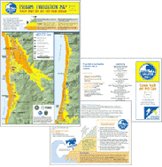 Neighborhood-Specific Evacuation Maps. If you are a resident living on the Oregon coast or a visitor, Oregon tsunami evacuation brochures for selected coastal communities may save your life. These detailed neighborhood maps were designed to be readable when printed on 8.5 x 11 inch paper. The maps direct visitors and residents away from low-lying areas in the event of a tsunami. Please take the time to read the brochures, become familiar with evacuation routes in your community and share what you have learned with your family and friends.
-
Large-Extent Evacuation Maps. These larger-area maps show the same evacuation zones as the neighborhood maps but cover larger areas, including most Oregon coast communities. They may not be readable when printed on standard printers. Please take the time to read the brochures, become familiar with evacuation routes in your community and share what you have learned with your family and friends.
-
 Interactive Evacuation Zone Viewer
Make a custom map for your area of interest with the
NANOOS evacuation zone web map viewer. Search by address or coastal area. The site also provides tips on tsunami preparedness, explanations of official tsunami warnings and other tsunami facts and information.
-
 Tsunami Inundation Maps. Oregon?s tsunami inundation maps provide scientists and the technical community (engineers, GIS analysts, community planners) descriptions of the extent of flooding predicted by sophisticated hydrodynamic computer models for multiple tsunami scenarios. These maps also provide information on expected tsunami arrival times, maximum flow depths, and maximum flow velocities for a range of tsunami simulations.
-
 Tsunami Inundation and Evacuation GIS Data via West Coast Ocean Data Portal. This data layer is an element of the Oregon GIS Framework. The evacuation zones are the local and distant tsunami scenarios shown on the tsunami evacuation brochures. These polygons represent the evacuation zones for the entire Oregon coast. All 7 tsunami scenarios, along with a text report and other supplemental files, can be found in DOGAMI Open-File Report O-13-19, Summary of Tsunami Hazard Data for Oregon (preview report).
What should I do if a tsunami evacuation map is not available for my area?
Make a custom map for your area of interest with the
NANOOS evacuation zone web map viewer. Search by address or coastal area. The site also provides tips on tsunami preparedness, explanations of official tsunami warnings and other tsunami facts and information.
Where can I find additional information?
Choose the group that reflects your interest: